The continued push of settler colonists up the valleys of the Kennebec and Penobscot rivers, at the expense of the Wabanaki, drove grand arguments and new visualizations of the economic value of interior lands. For the Commonwealth of Massachusetts, the district’s “empty” lands were to be divided into towns that could be sold off for income—whether to speculators, who sought to sell them on for a quick profit, or to proprietors, who sought to rent out the lands for long-term profit—or, donated in support of schools and improvements. Look around Moosehead Lake on any of the maps in this section, for example, to find towns granted to fund several academies, colleges, and worthy societies and to support the construction of the Middlesex (“MSX”) Canal. Look carefully and you will also find, now surrounded, the four “Indian Towns” reserved for the Penobscot in 1818 but usurped by the state in 1833.
The indefatigable entrepreneur Moses Greenleaf was a proponent of statehood and of the development of Maine’s interior. His large 1815 map of Maine demonstrated how the district had become self-supporting and how much territory remained to be developed [item 11]. With statehood in 1820, he quickly reissued the map with a new title: Map of the State of Maine [12].
Maine statehood was more a divorce than a parting of ways. The interior was a valuable joint asset that had to be divided equally between the commonwealth and the new state. New surveys divided up the interior into a checkerboard of commonwealth and state property. George Coffin, the Massachusetts land agent responsible for managing the commonwealth’s property, recorded the allocation in an 1835 map, labeling unsold towns “C” (commonwealth) or “M” (Maine) [13]. 13 is actually a recently restored damaged manuscript version of Coffin’s published map.
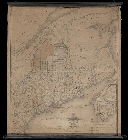
Greenleaf continued to promote the settlement and exploitation of interior lands as the future heart of Maine’s economy. In 1829 he published a larger map that situated Maine within the context of the Maritime provinces. The 1844 edition displayed here has been annotated in manuscript (unfortunately water damaged and partially faded) to show towns belonging to Massachusetts (red) and Maine (blue); the region still undivided and jointly owned (green); and the one town (brown) reserved for the Passamaquoddy under the 1794 treaty, in Washington County [14].
All these maps display the three periods of town creation in Maine: the chaotic, piecemeal jumble of colonial-era towns in the south; the middle tier of grids of towns created by the Commonwealth, angled because they were laid out to magnetic north; the northern grid of towns laid out after 1820 with respect to true north. Despite their similarities, there are many differences in the details of these maps. Henry David Thoreau wrote that Greenleaf’s large map was “a labyrinth of errors” and that Coffin’s map was the only reputable map of the interior.
11
Moses Greenleaf
Map of the District of Maine from the Latest and Best Authorities (Boston: Cummings and Hilliard, 1815).
Hand-colored, copper engraving in four sheets, 104 × 67 cm
OML Collections, Gift of Fleet Bank
https://oshermaps.org/map/112.0001
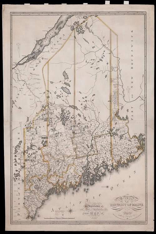
12
Moses Greenleaf
Map of the State of Maine from the Latest and Best Authorities (Boston, 1820).
Hand-colored, copper engraving in four sheets, 104 × 67 cm
Osher Collection
https://oshermaps.org/map/931.0001

13
George W. Coffin
“Plan of the Public Lands of the State of Maine, Surveyed under Instructions from the Commissioners & Agents of the States of Massachusetts and Maine” (ca. 1835).
Manuscript, 128 × 133 cm (if without loss)
OML Collections
https://oshermaps.org/map/42989.0001

Map Commentary by James E. Francis, Sr., Penobscot Tribal Historian and Director of Cultural and Historic Preservation
In the Treaty of 1818 between the Penobscot Nation and the Commonwealth of Massachusetts, the Penobscot retained land, which included all the Islands in the Penobscot River, two acres in Brewer, Maine, and four “upper” townships. On Coffin’s map from 1835, these townships are labeled as “Indian Townships.” They are located near modern day Mattawamkeag, on the east side of the Penobscot River (Indian Purchase 1), Woodville, on the west side of the Penobscot (Indian Purchase 2), near modern day Millinocket (Indian Township 3), and a township known today as Indian Purchase (Indian Township 4) just west of Millinocket. In 1833, however, despite the previous agreement in the Treaty of 1818, the lands were sold by the State of Maine. The Penobscot Nation refers to this as a “so-called sale,” as it was done without Penobscot approval and protests to the Governor were ignored.
In the first Legislature of the State of Maine, lawmakers granted themselves “paternalistic control” over the indigenous populations of Maine. Through State of Maine appointed Indian Agents, the State of Maine acted on what they felt was in the best interest of the Penobscot and Passamaquoddy tribes. The $50,000 sum for the sale of lands went into the State coffers. This was a paltry sum for lands that contained prime timber and river access. The Penobscot also valued this land as prime hunting grounds, to which they were subsequently denied access.
This land sale was in violation of the 1794 Trade and Non-intercourse Act, which requires U.S. Senate approval of any land transfers involving Native American lands. This act would later be the legal devise for the groundbreaking Maine Indian Claims Settlement Act in 1980.
14
Moses Greenleaf
Map of the State of Maine with the Province of New Brunswick (Portland: Shirley & Hyde, 1844).
Hand-colored copper engraving in four sheets, with manuscript annotations, 126.5 × 106 cm
Osher Collection
https://oshermaps.org/map/13296.0001